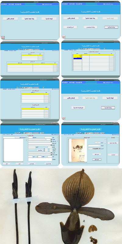

Electronic Herbarium
Developed and maintained by GeoTech for Saudi Wild Life AuthorityA Herbarium is a collection of preserved plant specimens with a label attached to indicate the place of occurrence, the name of collector, species name and identity. As Herbarium is the record of plant diversity of a geographical area, the development and maintenance of a herbarium is essential for the scientific studies on ecological sustainability. As other ecological conservation groups in KSA, Saudi Wild Life Authority is also involved in maintaining herbarium. They have a collection of more than 5000 species of plants collected since 1988, from different geographical areas of Saudi Arabia.
-
Challenge
Conventional methods of recording and describing flora employ drawing and logging coordinates, and taking samples to flatten and store in a herbarium, a controlled environment like a library or archive where samples are kept for safe-keeping. Multiple retrievals of this precious data can destroy its quality, and also has a limitation in sharing the herbarium data. This conventional type of herbarium is vulnerable to natural or manmade catastrophes.
-
Solution
An Electronic herbarium along with conventional system is essential to maximize the utility and safety of the valuable herbarium collection. We developed an Electronic Herbarium, which is more accessible and user-friendly. All the 5000 herbarium specimens were scanned and the images of the specimen and its attribute details are stored using an Oracle databases (Oracle Enterprise Database 11G). The spatial information of the specimen is stored using Oracle Spatial database, enabling a GIS-based visualisation of the occurrence of the plant species.
-
Result
An Electronic Herbarium system consisting of 5000 specimens was developed, tested and implemented. The System works by all major Internet browsers and with the latest versions of Java environment. The user interface is available in both Arabic and English. The user interface has modules to add more specimen, editing of entered data and retrieval of stored specimen information.
-
In addition, a geodatabase consisting of specimens with the location, topographic maps, satellite images, soil map, road map, political boundaries and spatial distribution of metrological events has been developed, enabling the user to do spatial analysis.